
LiDAR SERVICES
- Topo’s/Contour
- Construction
- Clash detection
- As-Built/BIM
- Excavation Assessment
- Inspection
- Mapping/Survey*
- ALTA
- Site Inspection
- Mining
- Stockpile/volumetrics
- Slope Stability
- Environmental Impact Assessments
- Forestry
- Tree Density
- Invasive Species Detection
- Farming
- Crop Health Analysis
- Irrigation Planning & Runoff
- Archeology
- Geology
- Fault/landform analysis
- Landslide Risk Assessment
- Earthquake damage Assessment
- Forensics
- Evidence collection/documentation
- Visualized crash dynamics
- Skidmark & debris analysis
- Scene Reconstruction
Land Development
This development site was captured with a Microdrone EasyOne with the UHR payload, in under 6 minutes of flight, processed in 15 minutes, and delivered two hours after flight as an .LAS file

LiDAR (Light Detection and Ranging) offers great benefit to our clients. Not only is the data remarkably fast to capture and deliver in raw form, it is extremely flexible and may be used by general contractors, survey firms, site developers, infrastructure inspection teams, and so many other applications, we haven’t found any targets which cannot be captured well with LiDAR via aerial transport
WHY LiDAR?
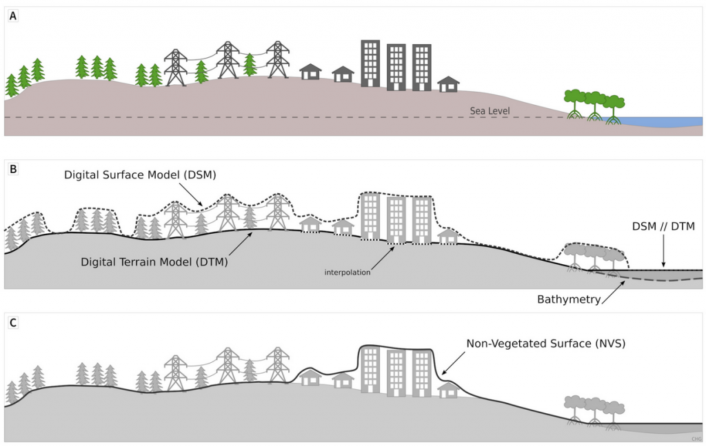
Speed, accuracy, precision, and compatibility with virtually any VDC applications ranging from LP360, Pix4D, Leica 3DR, AutoCAD, and more. Further, SMG LiDAR systems are capable of penetration of heavy foliage, providing engineers with DSM, DTM, DEM, and other relevant outputs.
Cost is another significant factor in use of LiDAR. Small areas are vastly less expensive and faster to process, cutting time from conception to delivered datafiles, regardless of whether our team provides the analytics, or client teams ingest unfinished .LAS/.LAZ files.
THIS IS A TEMP IMAGE!!
On the left are many uses for LiDAR and what sorts of environments our team has worked in/delivered from.
Although we are not subject matter experts in some of these environments, we excel in precision capture of accurate data in all environments. Some of our clients prefer we process data start to finish, as we have many years of experience in the Construction, Survey, Inspection, and Forestry industries, while other clients prefer to receive .LAS or .LAZ files from directly processed after flight.
In most cases, .LAS or .LAZ files may be processed same/next day for rapid service.
SMG uses Microdrones EasyOne aircraft paired with GeoGue sensors for the best-in-class service. Our NATO-Compliant systems are cleared for NDAA/Federal use on Federal assets (No Chinese components in our systems). We offer a broad variety of processing platforms, dependent on client preferences, delivery needs, file format requirements, and depth of processing. Files are delivered securely over the internet, on ground-delivered thumbdrives, or other preferred methods of delivery. We also deliver file-viewers for clients uninterested in processing in-house, or for those not entirely familiar with how to access, view, analyze, and share LiDAR file formats. While not difficult, it may be unfamiliar to newer users of LiDAR datasets.
")